Francis Scott Key Bridge in Baltimore Collapse

A tragic ship collision caused the Key Bridge to collapse like a house of cards on March 26, 2024.

In the wee hours of a cold March morning, a large freighter, the Dali, lost power and steerage control and collided with a major support of the Francis Scott Key Bridge in Baltimore, Maryland. The collision occurred at 1:28 AM and caused the main supporting structure to fail and the bridge spans to, literally, fall apart.

Imagine the chaos that ensued when a massive freighter collided with the Francis Scott Key Bridge, causing sections to collapse into the Patapsco River below. The sheer force of impact from the container ship left onlookers stunned and authorities scrambling to respond to this unprecedented disaster. As emergency crews rushed to the scene, questions arose about how such a catastrophe could have occurred in one of the busiest waterways in Maryland. This disaster effectively closed the (very busy) Port of Baltimore for an indeterminant length of time.

Francis Scott Key Bridge as seen from the sea wall at Fort McHenry
Francis Scott Key Bridge as seen from the sea wall at Fort McHenry in 2017, 40 years after it opened.

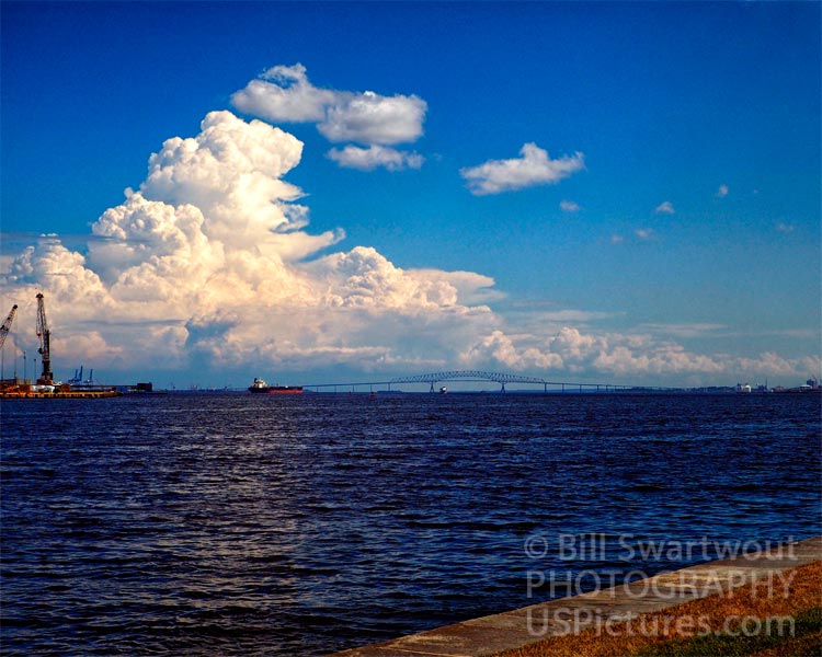
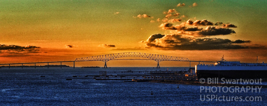
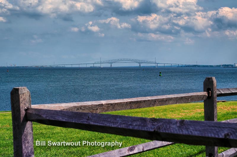
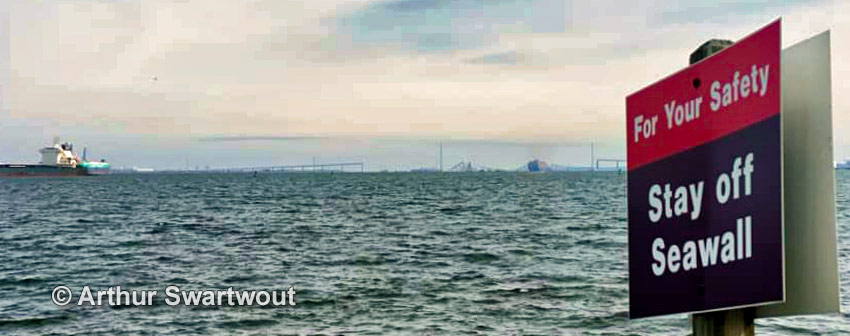
The Key Bridge was opened for use in 1977. This author can remember watching the construction process for the years before the opening. The full name is, of course, derived from the lawyer, Francis Scott Key, who penned the words to our National Anthem, the Star Spangled Banner.

FSK Bridge as seen from Fort McHenry
FSK Bridge as seen from Fort McHenry, about four miles to the west.

In conclusion

The collapse of the Francis Scott Key Bridge in Baltimore sent shockwaves through the city as the iconic structure crumbled into the Patapsco River. The aftermath of the bridge collapse revealed a startling vulnerability in our infrastructure and raised concerns about the safety of maritime navigation through this vital transportation corridor at the state and national levels. Investigations underway and repair efforts are already being planned. One can’t help but wonder about the long-term implications of this incident on shipping traffic and regional economy. As we await updates on this developing story, it’s clear that lessons must be learned from this tragic event to prevent similar disasters in the future.

Francis Scott Key Bridge after the collapse
Francis Scott Key Bridge the day after the collapse – Photo by Arthur Swartwout.

For many, this catastrophic event raised questions about infrastructure resilience and safety in a rapidly changing world. In moments like these, we are reminded that even our most trusted landmarks are vulnerable to unexpected challenges and that vigilance and care must be paramount in safeguarding our communities from potential disaster.

Francis Scott Key Bridge from the Rodman Cannons at Fort McHenry

Visit www.FSKBridge.com for more photos of the Key Bridge as it used to be.


Arthur Ravenel Jr. Bridge Wall Art

Framed by palm trees, this picturesque bridge photograph will look wonderful in your home or office.

The Arthur Ravenel Jr. Bridge is an architectural wonder. Designed by the renowned firm of Cline Design Associates, this cable-stayed bridge spans the Cooper River and connects Charleston to Mount Pleasant, South Carolina. This bridge was opened on July 16, 2005 and replaced two older bridges, the Silas N. Pearman Bridge and the John P. Grace Memorial Bridge (built in 1929 and 1966).

Arthur Ravenel Jr. Bridge, Charleston, SC
An architectural wonder, the Arthur Ravenel, Jr. Bridge crosses the Cooper River at Charleston, South Carolina.

At a total length of 13,200 feet this is the third longest cable-stayed bridge in the western hemisphere with a main span of 1,546 feet and a clearance of 187 feet. In 2006, it won an Outstanding Civil Engineering Achievement award from ASCE for its innovative design and materials. The bridge has eight lanes for vehicular travel and two bicycle/pedestrian lanes so you can see it up close!

Arthur Ravenel Jr. Bridge Panorama Format
Arthur Ravenel Jr. Bridge Panorama Format 3:1

An infrastructure wonder, it is the third longest cable-stayed bridge in the western hemisphere and offers panoramic views that are especially striking at sunset.

Arthur Ravenel Jr. Bridge Panorama Format 2
Arthur Ravenel Jr. Bridge Panorama Format 2:1


The Arthur Ravenel, Jr. Bridge (sometimes referred to as the New Cooper River Bridge) is a cable-stayed bridge over the Cooper River in South Carolina. Opened to traffic nearly two decades ago, the 1,546 foot long bridge carries eight travel lanes and two wide outside shoulders. It is held aloft by two 600-foot concrete pylons that support a 650-foot center span and a pair of 350-foot side spans. Total length of the bridge is 13,200 feet or 2.5 miles. With its main span rising only 187 feet above mean high water, the bridge carries Interstate 526 across Charleston Harbor from Patriots Point to U.S. Highway 17 at Mount Pleasant.


The Arthur Ravenel Jr. Bridge is a cable-stayed bridge over the Cooper River in South Carolina, connecting Charleston to Mount Pleasant. It replaced two obsolete cantilever truss bridges. Its eight lanes carry U.S. Highway 17, U.S. Highway 52, and South Carolina Highway 7 as it crosses the river, with a dedicated bicycle and pedestrian lane along the northern side of the bridge.


Imagine if a bridge could talk: “I am the Arthur Ravenel Jr. Bridge in South Carolina, named after a politician who served as state senator and member of the United States House of Representatives. I am a cable-stayed bridge that crosses the Cooper River at Charleston, South Carolina. I opened on July 16, 2005, and was built to replace two aging bridges: one which carried U.S. Route 17 over the Cooper River and another which carried U.S. Route 17 over the Wando River. I connect Charleston to Mount Pleasant, South Carolina.

Link: Arthur Ravenel Jr. Bridge in the Palms (free shipping)

Link: Arthur Ravenel Jr. Bridge Panorama Format 3:1 (free shipping)

Link: Arthur Ravenel Jr. Bridge Panorama Format 2:1 (free shipping)

Link to: Bill’s Pictorem Gallery

Link to: Bill’s FineArtAmerica/Pixels Gallery

Waccamaw River Memorial Bridge

This historic Bridge in Conway, South Carolina carries travelers across the Waccamaw River.

Built in 1937, the Waccamaw Memorial Bridge (also referred to as the Conway Memorial Bridge) is a historic plate-girder bridge in Conway, Horry County, South Carolina. This plate deck girder bridge, with Gothic-style arches is designated a memorial to Horry County soldiers who served in America’s wars from the Revolution to World War I. This bridge was built to relieve the traffic congestion of the original one-lane bridge as popularity grew for the Grand Strand resort of Myrtle Beach. It was listed under National Register of Historic Places on October 12, 1999.

Conway Memorial Bridge over the Waccamaw River in Conway, Horry County, South Carolina.

This photograph was taken while enjoying a walk along part of the Conway Riverwalk. The Riverwalk is a sculpted boardwalk with railings along much of the town’s waterfront on the Waccamaw River. If you, one day, get to visit Conway, be sure not to miss a stroll along the river. 

Conceived a the height of the Great Depression and at a cost of $370,000, Horry County’s fifth bridge across the Waccamaw River was constructed just prior to the years of World War II. The Waccamaw River Bridge carries Business Route U.S. Highway 501  over top of the Waccamaw River connecting North Conway to Aynor/Yauhannah, South Carolina.

Waccamau River Memorial Bridge in Black and White
The Waccamaw River Memorial Bridge in a Black and White Presentation

Click the photo above or the links below to see wall art with this image along with an assortment of home decor items. 

Link: Waccamaw River Memorial Bridge at Conway, SC

Link: Waccamaw River Memorial Bridge at Conway in Black and White

Link to: Bills Full Gallery at Pictorem (Free Shipping)

Link to: Bill’s Gallery with Fine Art America

What’s that, Myrtle Beach? You’ve been under stress from the lack of a second bridge crossing the Waccamaw River for half a century? Well, we’ve got just the thing to lift your spirits: The Waccamaw River Memorial Bridge! This historic bridge is located in Conway, South Carolina, and carries travelers over the Waccamaw River. It was built in 1937 as a replacement for the original bridge (built in 1921), which could not accommodate all of the travelers to and from Grand Strand resorts. The new bridge was designed as a plate deck girder bridge in a Gothic-style arch with reinforced concrete piers, abutments and wing walls. In 1998, the State of South Carolina designated the bridge as a memorial to Horry County soldiers who served in America’s wars from the Revolution to World War I. This made it one of two bridges in South Carolina with such designation (the other is located near Kingstree). The bridge spans 1,024 feet (312 m) across the river, including approach spans. It measures 16 feet (4.9 m) wide and 8 feet (2.4 m) high.

Indian River Bridge Clouds Wall Art

The Indian River Inlet Bridge near Bethany Beach, DE appears different every time we are there.

These clouds predict the onset of a storm but, in this case it was just an illusion. It was 40 degrees and windy, up from a low of 19, when this photograph was captured.

The George W. Cullen Bridge over the Indian River Inlet is located between the coastal towns of Dewey Beach and Bethany Beach , Delaware. It is surrounded by the public beach, marina and campground facilities of the Delaware Seashore State Park.

Indian River Bridge Clouds

In addition to the full color version, this is the black and white presentation “Indian River Bridge Clouds” and is unique in its own right.

Indian River Bridge Clouds in Black and White

Use the links below to see larger versions of the Indian River Bridge Clouds and to browse or shop the variety of wall art and home decor items available.

Link: Indian River Bridge Clouds

Link: Indian River Bridge Clouds in Black and White

Link to: Bill’s Indian River Bridge Gallery at Fine Art America

Link to: Bill’s Indian River Bridge Gallery at Pictorem (w/ Free Shipping)

When I wanted to photograph the Indian River Inlet Bridge near Bethany Beach, DE I knew that weather could be an obstacle. Sure enough, before sunset a warm front arrived, with at layers of clouds moving in from the west. But this time Mother Nature played a trick on me. The sky was filled with these ominous clouds and snow flurries started to fall, much like in this photograph. Even though it was cold and the wind was blowing, I had to wait until everything came together. I was hoping for a bit more color. But this cloudy scene doesn’t lack interest – in my opinion. Toned sky, ragged clouds and stark and empty rocky jetty on the north side of the Indian River Inlet are what makes this scene so striking!

Baltimore Inner Harbor Panorama Wall Art

How Downtown Baltimore looked nearly two decades ago.

This Baltimore Inner Harbor photograph is one of the most popular, as being one of the first images to be sold multiple times over the nearly 20 years since the Baltimore City skyline looked this way. What differences could you see today – if you were to trek to the top of Federal Hill Park in South Baltimore to view this vista in person?

Baltimore Inner Harbor Panorama Original

The same image is also available in a black and white presentation. This view emphasized the lines and shape of the city skyline as opposed to making an overall statement in color. A lot can be said for black and white images in a contemporary setting, such as a modern home or an office. Especially an office in one of the buildings in this nearly two decade old photograph

Baltimore Inner Harbor Panorama Black and White

This image has appeared in countless conference pamphlets over the years, it is in print in a book on Urban Geography by the Harvard University Press and was even used by the City of Baltimore at a “sister cities” conference in The Netherlands.

Links to larger images and to browse or buy.

Link: Baltimore Inner Harbor Panorama Photograph

Link: Baltimore Inner Harbor Panorama in Black and White

Link to: Baltimore Collection at Fine Art America

Link to: Baltimore Collection at Pictorem (w/ Free Shipping)

Notes: The decade-old photograph of the famous Baltimore Inner Harbor is a compilation of four images “stitched” together, yet is still relevant today. There are some differences over the last dozen or so years. Can you spot them? Imagine the differences from the time Fort McHenry defended Baltimore during the War of 1812. Imagine how this city might appear if the British Invasion was not thwarted.

Ocean City Boardwalk Arch Wall Art

This iconic boardwalk sign greets visitors to Ocean City, Maryland as they enter town from Route 50.

The iconic Ocean City, Maryland Boardwalk Arch greets visitors as they enter Ocean City from the west, along Route 50 and North Division Street. This welcoming sign greets visitors to the beach and boardwalk, just as a print of this can greet visitors in your home or office.

Ocean City Boardwalk Arch

Beach and boardwalk greetings are a tradition no matter where in the world you live, but in Ocean City, Maryland, it is THE tradition.

Ocean City Boardwalk Arch Enhanced

Here is a black and white presentation of the Boardwalk Arch for those of you who prefer monochrome images as home or office decor.

Ocean City Boardwalk Arch Black and White

Where to find prints and home decor featuring one of these photographs…

Link: Ocean City Boardwalk Arch

Link: Boardwalk in Ocean City – Enhanced

Link: Ocean City Boardwalk Arch Black and White

Link to: Bill’s Fine Art America Gallery

Link to: Bill’s Pictorem Gallery (w/ Free Shipping)

The Boardwalk sign was built in 2000 but The Boardwalk, officially known as Atlantic Avenue, dates back to 1902, when several oceanfront hotel owners got together and constructed a wooden walkway for the convenience of their guests. At high tide, it was rolled up and stored on hotel porches. Around 1910, a permanent promenade was built.

Welcoming visitors to the beach and sands of Ocean City, the iconic Arch greets cars along Route 50 and North Division Street. This work of art has stood tall since 2000 and brings joy to beachgoers with every visit.

For more than two decades, visitors to beautiful Ocean City, Maryland have been greeted by this historic structure on the Atlantic coast. Our beautiful interpretation is a perfect accent for your home or office.

Baltimore World Trade Center and USS Constellation

Photographs of an iconic skyscraper and an historical ship in the Baltimore Inner Harbor.

Baltimore’s World Trade Center on Pratt Street in downtown Baltimore stands tall above the historic USS Constellation, the only surviving ship from the Civil War era, in the famous Inner Harbor.

Baltimore World trade Center and USS Constellation

This photograph of two of Baltimore’s best-known landmarks is also available in a black and white presentation.

Baltimore World trade Center and USS Constellation in Black and White

Here is where to see larger images and browse wall art and home decor items.

Link: Baltimore World Trade Center and Constellation

Link: Baltimore World Trade Center and USS Constellation Monochrome

Link to: The Baltimore and the Inner Harbor Wall Art Collection.

The Baltimore World Trade Center stands tall above the historic Constellation in the Baltimore Inner Harbor. It offers stunning views of the harbor, downtown Baltimore and beyond.

What do you see? In this image, the Baltimore World Trade Center stands tall above the historic USS Constellation. The Baltimore’s WTC stands 400 feet above this Maryland city’s waterfront promenade.

At the top of the Baltimore World Trade Center is an observation deck. While you’re there, you might want to check out the nearby USS Constellation, a former Navy ship that later became a museum and attraction in Baltimore’s Inner Harbor. Both are excellent photo opportunities–the former for a picture-perfect view of Baltimore and the latter because it’s way cool.

You’ve been burning the midnight oil but now it’s time to take a break. After grabbing a quick snack, you decide to take the elevator up to the observation deck of Baltimore’s World Trade Center. Wow, what a view! It almost seems like you are floating above the city in some kind of tall ship. Below you can see the historic Constellation and the Domino Sugars sign off in the distance. Across the water, on the south shore, you can see the tall and grassy Federal Hill Park that overlooks the Inner Harbor. You head back down to your hotel room (office, apartment) and smile as you notice everyone seems to be smiling as well.

The World Trade Center, designed by architectural firm Pei Cobb Freed & Partners, is the crown jewel of Baltimore’s Inner Harbor. The juxtaposition between this contemporary building and the adjacent historic buildings—including the National Aquarium—adds to its grandeur. The World Trade Center was featured in the 2014 movie The Fault in Our Stars.

The Baltimore World Trade Center and USS Constellation wall art is a must-have piece of Baltimore memorabilia. Our photo print is available as a ready to hang poster, a photo blanket, a travel mug and more.

Dramatic and graceful, the wonderful work of architecture is one of Baltimore’s most beloved landmarks. Its unique spherical observation deck is located a third of the way up the building, with windows that offer extraordinary views of the harbor, city, and surrounding areas.

Link: Baltimore World Trade Center and Constellation

Link: Baltimore World Trade Center and USS Constellation Monochrome

Link to: The Baltimore and the Inner Harbor Wall Art Collection.

Fenwick Island Lighthouse Wall Art Photographs

An early morning clear blue sky provides a fine backdrop for the first of these “looking upward” views of the light.

The Fenwick Light is located on the state line border between Delaware and Maryland. It is just inside the town of Fenwick Island, Delaware and just across the line from Ocean City, Maryland. The Fenwick Island Lighthouse was first lit on November 10, 1808.

An early morning clear blue sky provides a fine backdrop for this first “looking upward” view of the Fenwick Island Lighthouse.

Fenwick Island Lighthouse in a Blue Sky

An unusual Mackerel Sky frames this wide angle shot of the Fenwick Island Lighthouse just north of the state line between Maryland and Delaware. 

Fenwick Island Lighthouse in a Mackerel Sky

An unusual Mackerel Sky, in a black and white presentation, frames this wide angle shot of the Fenwick Island Light with an added “star filter” for emphasis on the light. The images above are also available in B&W without the additional edit.

Fenwick Island Lighthouse in Black and White with Star

Links to: the Fenwick Island Lighthouse in my Fine Art America/Pixels Gallery.

Links to: the Fenwick Island Lighthouse Lens at Pictorem.

The above are but a few sample of my photographs of the Fenwick Island Light. I love to showcase and preserve the unique beauty in and around my Coastal Delaware home. This lighthouse landscape photography is just one of a wide variety of memorable photographic opportunities that make online galleries unique.

Fenwick Island is located on the state border of Delaware and Maryland, and there are a few places along the boardwalk where you can get right up to the line. I was lucky enough to be in this place at sunset when the light was all aglow. This photograph is one of a series that I took during my trip recently.

Whoa! It’s a bird, it’s a plane–it’s a photograph of the Fenwick Light. You can bring this state line landmark into your home with the help of these high quality art photographs.

I’ve have the pleasure of photographing the Fenwick Island Lighthouse at various times. These photographs come in many sizes, and will look great wherever you place them.

Delaware. The Fenwick Island Lighthouse Preservation Society will keep this light at its current location. A prime spot for photographing the summer sunsets of Ocean City, Maryland and the summer sunrise of Rehoboth Beach,

Fenwick Island Light, also known as Fenwick Island Lighthouse, is located just inside the limits of the town of Fenwick, in the state of Delaware. When it was built in 1866, it was one of the first 50 lighthouses to be established by the federal government. It is a conical, rubble stone light and is a height of 128 feet.

Fenwick Island Light is one of the few remaining lighthouses in Delaware, and is located within the vacation destination of Fenwick Island. It’s location enabled it to serve as a navigation beacon for mariners sailing along the Delaware and Maryland coasts.

In the early 19th century, mariners from colonial Delaware and Maryland operated a series of beacons to protect them from sandbars and other hazards along their coastlines. Today, one of these lighthouses still shines over Fenwick Island.

I’m a photographer. That’s my job. My passion is photography and my favorite thing to do is shoot coastal and coast-related images. There’s something very calming and peaceful about being near the ocean beach. I am a skilled photo guy who likes to travel and make photographs of places I’ve been. I don’t set out to produce amazing art. If I do, then that’s just a bonus.

This is where I live. It’s nice here, but you have to watch out for the flying fish. (That joke isn’t even funny… it’s just inside Delaware.)

Looking for a fun way to brighten up your office? Need a gift idea that’s both quirky and useful? These trendy, affordable wall art prints will provide both. Perfect for children’s rooms, too! (copy.ai)