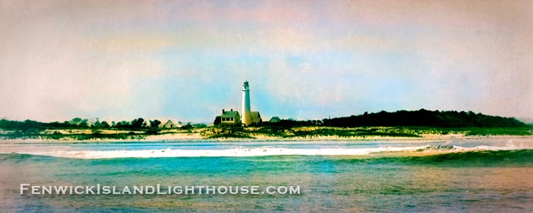
Here is a “colorized” image from more than a century ago.
Built in 1858, the Fenwick Island Lighthouse stands as a beacon of history for the small towns of Fenwick Island, Delaware and Ocean City, Maryland.
Fenwick Island Lighthouse “colorized” panorama photograph.
Looking way back, this panorama photograph of the Fenwick Island Lighthouse in coastal Delaware was created and colorized from an 1891 faded black and white image downloaded from the United States National Archive website.
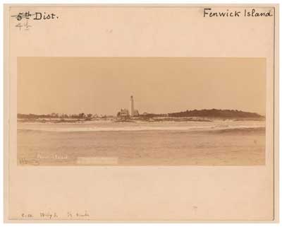
The Fenwick Island Light Station from the National Archives, National Museum of American History
The Fenwick Island Lighthouse Station has been aiding navigation for mariners since August 1, 1859. Today, the historic structure is a popular tourist destination, especially for photography enthusiasts. The “Fenwick Light” is an historic landmark located in southernmost Delaware right at the border with Ocean City, Maryland.
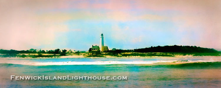
Fenwick island Lighthouse Panorama processed as an abstract to give it a more “painterly” appearance.
Oldest Lighthouse in Delaware
A quote from the website: “The official opening of the Fenwick Island Lighthouse, when the light was first lit as an aid to navigation, was on August 1, 1859.” That makes the Fenwick Island Light the oldest lighthouse in Delaware.
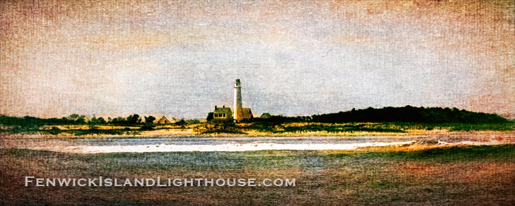
Fenwick Island Lighthouse as a simulated canvas painting.
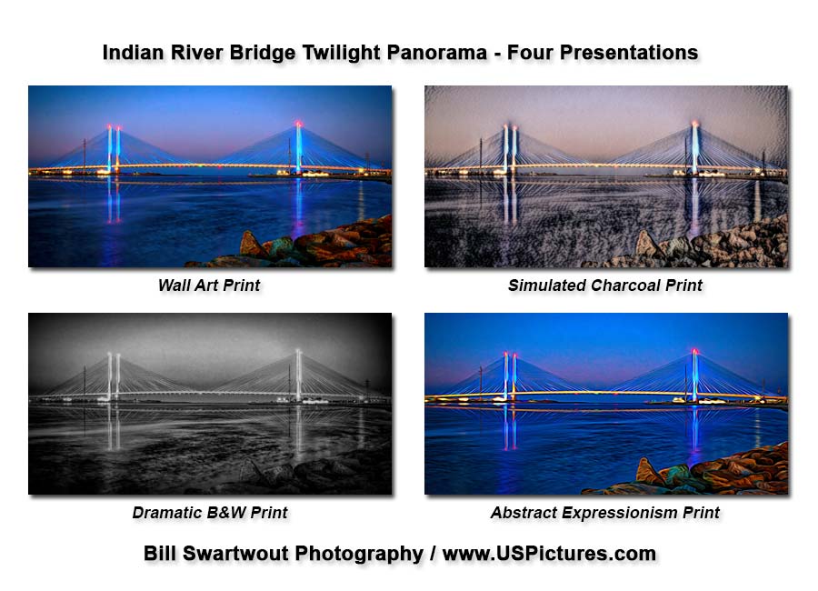
Four styles of this popular photograph are now available in a 2:1 panorama ratio.
I’ve had requests for a more-panorama-shape of one of my most popular photographs of the Indian River Inlet Bridge. So I made a “regular” Panorama (2:1 ratio) and three additional presentations. Might you be interested in any of these please let me know. If so, which one? Leave a response in the comments section at the bottom of the page.
Indian River Inlet Bridge at Twilight Panorama Photograph in Four Presentations.
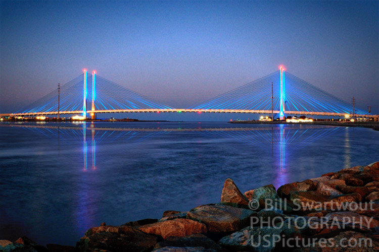
The Charles W. Cullen Bridge is the official name of this beautiful example of cable-stayed suspension bridge architecture. The Indian River Inlet Bridge carries coastal traffic on Route 1 across the Indian River Inlet just north of Bethany Beach Delaware.
This beautiful structure is sight to behold at any time of day or night. However, twilight, the transition between day and night, brings out the spectacular color of the bridge, the water and the sky – all in shades of blue – at this magical time.
The Indian River inlet joins the Rehoboth Bay and the Indian River Bay with the Atlantic Ocean. The Indian River Bridge over the inlet allows traffic to flow north and south along “Coastal Highway” (Route 1), connecting several beach resort towns from Ocean City in Maryland to Rehoboth Beach and Lewes in Delaware.
The Delaware Seashore State Park facilities on both the north and south sides of the Indian River Inlet and along the shore of the Indian River Bay attract thousands or people, who can enjoy sights like this, all year ’round. The area, just north of Bethany Beach, DE boasts campgrounds, a large marina, fishing and, of course, a well-maintained and guarded (in season) beach on the Atlantic Ocean.
The original “best selling” print: Indian River Inlet Bridge Twilight Reflection
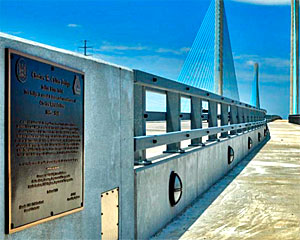
Charles W. Cullen Bridge – Dedicated 2012
Dedication Plaque on the Indian River Bridge Pedestrian Walkway
This bridge is named in honor and remembrance of Charles West Cullen, 1865-1948, a man who dedicated his life to public service and the the citizens of Delaware. Between 1930 and 1940, he served on the State Highway Commission, eventually being elevated to Chairman of the Commission from 1938-1939. While he was Chairman, work was started on a new bridge to span the Indian River Inlet. In recognition for his service on the Commission, the bridge was dedicated on May 18, 1940, in his name for his advocacy for the proper opening of the inlet and the internal development of the Indian River. Two additional bridges bearing his name have spanned the inlet since that time. This, the fifth bridge to span the inlet waterway, is was also dedicated in his name. (Paraphrased from the bridge dedication plaque.)
Use the links below to browse or shop more of Bill’s photographs of the Indian River Inlet Bridge.
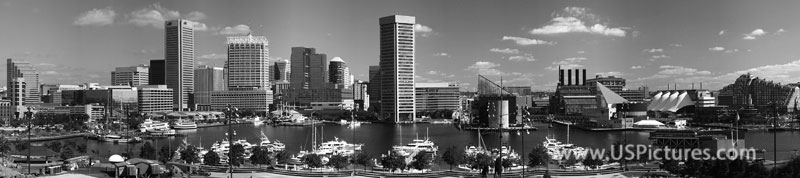
How Downtown Baltimore looked nearly two decades ago.
This Baltimore Inner Harbor photograph is one of the most popular, as being one of the first images to be sold multiple times over the nearly 20 years since the Baltimore City skyline looked this way. What differences could you see today – if you were to trek to the top of Federal Hill Park in South Baltimore to view this vista in person?
The same image is also available in a black and white presentation. This view emphasized the lines and shape of the city skyline as opposed to making an overall statement in color. A lot can be said for black and white images in a contemporary setting, such as a modern home or an office. Especially an office in one of the buildings in this nearly two decade old photograph
This image has appeared in countless conference pamphlets over the years, it is in print in a book on Urban Geography by the Harvard University Press and was even used by the City of Baltimore at a “sister cities” conference in The Netherlands.
Notes: The decade-old photograph of the famous Baltimore Inner Harbor is a compilation of four images “stitched” together, yet is still relevant today. There are some differences over the last dozen or so years. Can you spot them? Imagine the differences from the time Fort McHenry defended Baltimore during the War of 1812. Imagine how this city might appear if the British Invasion was not thwarted.